Insurance claims management software for Australian carriers
In a CAT event, the carriers who reach customers first — with accurate damage assessments, and fast measurements — are the ones who build lasting loyalty. Nearmap provides claims management software to give your teams everything they need to act before the competition, settle faster than the industry standard, and get policyholders back on track sooner.

Create loyal customers with quicker claims

Day-to-day claims
Expedite your day-to-day claims process to provide superior customer service and adjust claims accurately.
With a visual source of truth to identify discrepancies and pre-existing damages, claims teams can make more informed decisions and prevent unnecessary payouts.
Claims investigators can confirm repair work remotely as new aerial imagery is available (updated up to 6 times a year), ensuring accuracy in claims and reducing the need for onsite inspections.
By sharing imagery and detailed reports, claims teams can clearly communicate with policyholders about claim progress and decisions.
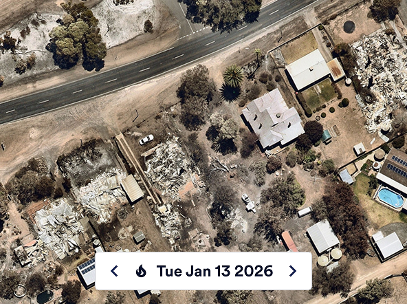
Post-disaster imagery before most adjusters can mobilise
Nearmap ImpactResponse delivers high-resolution post-event imagery as early as 24–48 hours of a qualifying disaster, giving claims teams a property-level view of damage before the first notice of loss has been filed. Pair post-event imagery with our historical archive for instant before-and-after comparison.

Be ready to act when the storm clears
Nearmap ImpactResponse lets you identify every insured property in a storm’s projected path. Stage loss adjusters in the right locations, predict claim volume by geography, and prepare reserves based on modeled exposure rather than historical averages. When the event passes, triage impacted policies immediately and direct adjusters to the properties with the greatest damage or most complex claims.
Post-event imagery combined with AI-powered damage classification gives your team the ability to identify affected properties and initiate contact before most policyholders have returned home. Kin Insurance assessed 40,000 properties remotely after Hurricane Ian and supported more than 50% of total claimants within the first five days — without a single adjuster visiting a site. That’s what proactive CAT response looks like in practice.

AI-powered damage detection assesses individual properties across your entire portfolio automatically, giving you an accurate picture of real losses soon after a CAT event. Accurate reserves from day one mean faster claims payments, fewer supplements, and lower loss-adjustment expenses across the portfolio. No waiting. No estimating. No catching up.


Insurance claims management
Claims management software gives carriers a faster, more defensible path from first notice of loss to settlement.
Flood claims follow three stages, and aerial intelligence supports each one. Flood zone identification gives underwriting and claims teams a property-level view of which homes and businesses sit in mapped flood zones, and pre-event exposure mapping places that view over a carrier’s portfolio so teams can anticipate claim volumes before the water arrives. After the flood, aerial assessment lets adjusters confirm damage remotely and prioritise the properties in greatest need.
“Nearmap provided us another verification layer. We could actually see if there was any sign of fire near the area in question, and the exact distance from the property to fire damage so our grants team could determine eligibility.”
Business Analyst
“The imagery and data provided by Nearmap before and after the storm allowed us to more accurately predict which homeowners would be impacted by the storm.”
Adam Sturt, SVP of Data and Analytics
Fast CAT data for faster response times
Streamline your claims and post-catastrophe inspections with rapid impact intelligence.
Applications

Imagery
